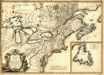
Representing their rightful claim as confirmed by charters and the formal surrender of their Indian friends, likewise the encroachments of the French, with the several forts they have unjustly erected therein. Society of Anti-Gallicans. CREATED/PUBLISHED London, Sold by Wm. Herbert … , 1755. NOTES Scale ca. 1:7,200,000. Hand colored. Relief shown pictorially. 'Longitude west from Ferro.' 'Sold by Wm. Herbert … & Robt. Sayer … ' Includes notes. Maps in margin: A plan of the harbor and town of Louisbourg on the isle of Cape Briton.–A plan of Chebucto Harbor.–The Atlantic Ocean.–Fort Frederick built by the French at Crown or Scalp Point in the year 1731.–A plan of Port Dauphin on the isle of Cape Briton.–A plan of the harbour of Annopolis Royal.–A plan of the town of Quebeck.
A new and accurate map of the English empire in North America
$17.95 – $47.95
SKU: rwcaar006200
Related products
-

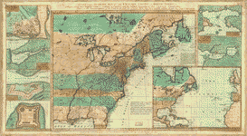
Carte du Canada et des Etats-Unis de l'Amerique Septentrionale
$17.95 – $47.95 -
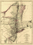
A map of the provinces of New-York and New-Yersey
$17.95 – $47.95 -
The provinces of New York and New Jersey
$17.95 – $47.95