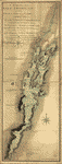
With part of Pensilvania, and the province of Quebec. Drawn by Major Holland, Surveyor General, of the Northern District in America. Corrected and improved, from the original materials, by Governr. Pownall, Member of Parliament, 1776. Pownall, Thomas, 1722-1805. CREATED/PUBLISHED London, Robt. Sayer & John Bennett, 1776. NOTES Scale ca. 1:650,000. Hand colored. Relief shown pictorially. Shows administrative divisions. Insets: A chart of the mouth of Hudson's River, from Sandy Hook to New York.–A plan of the city of New York.–Plan of Amboy, with its environs, from an actual survey.

The provinces of New York and New Jersey
$17.95 – $47.95
SKU: rwcact000082
Related products
-

A survey of Lake Champlain including Crown Point and St Iohn's
$17.95 – $47.95 -
Canada et Louisiane
$17.95 – $47.95 -
Canada et Louisiane
$17.95 – $47.95 -
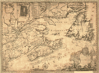
This map of the province of Nova-Scotia and parts adjacent
$17.95 – $47.95