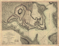
As taken by His Majesty's forces under the command of Genl. Sr. Henry Clinton the 6th. of Octr. 1777. Survey'd by Major Holland, surr. genl. of the Northern District of North America. Holland, Samuel, 1728-1801. CREATED/PUBLISHED [1777] NOTES Scale ca. 1:18,000 (not ca. 1:6,000 as depicted by bar scale). Has watermarks. Relief shown by hachures. Pictorial map.

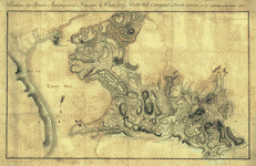
A plan of the Forts Montgomery & Clinton
$17.95 – $47.95
SKU: rwnyar118900
Related products
-

A Map of Ticonderoga
$17.95 – $47.95 -
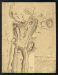
Position des Armees ameriquaine et francoise a Kings-ferry
$17.95 – $47.95 -
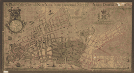
A plan of the city of New York from an actual survey
$17.95 – $47.95