Home
All Products
Historic Maps
American Indian Maps
Birds Eye View Maps
Civil War Maps
Panoramic Maps
Railroad Maps
Revolutionary War Maps
State Maps
Historic Prints
Civil War Prints
Civil War Posters
Historic Portraits
Presidential Portraits
Contact Us
0
0
press
Enter
to search
Showing all results:
No products found.
Home
/
State Maps
/
Tennessee
/
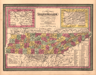
A new map of Tennessee
$
17.95
–
$
47.95
SKU: smtn11
Paper Size
Choose an option
12" x 18"
18" x 24"
24" x 36"
Clear
Quantity
Qty
Add to cart
Description
Cowperthwait, Thomas. CREATED/PUBLISHED [S.l.], 1850.
SKU:
smtn11
Category:
Tennessee
Related products
Sketch of the battles of Chattanooga, Nov. 23-26, 1863 U.S. Coast Survey Office, A. D. Bache Supdt
$
17.95
–
$
47.95
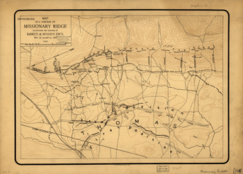
Map of a portion of Missionary Ridge
$
17.95
–
$
47.95
Fisheye view of Chattanooga and vicinity showing troop positions in 1863
$
17.95
–
$
47.95
Plat of Murfreesboro. Taken from a top'l. sketch of Murfreesboro and its environs
$
17.95
–
$
47.95
Search Product or SKU
×
Home
All Products
Historic Maps
American Indian Maps
Birds Eye View Maps
Civil War Maps
Panoramic Maps
Railroad Maps
Revolutionary War Maps
State Maps
Historic Prints
Civil War Prints
Civil War Posters
Historic Portraits
Presidential Portraits
Contact Us
Cart
0
Cart
Close
Updating…
No products in the cart.
Continue shopping