Home
All Products
Historic Maps
American Indian Maps
Birds Eye View Maps
Civil War Maps
Panoramic Maps
Railroad Maps
Revolutionary War Maps
State Maps
Historic Prints
Civil War Prints
Civil War Posters
Historic Portraits
Presidential Portraits
Contact Us
0
0
Search Product or SKU
×
press
Enter
to search
Showing all results:
No products found.
Home
/
State Maps
/
New York
/
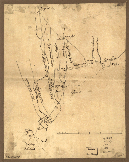
Map of the roads from New Rochelle to Kingstreet, Westchester County.
$
17.95
–
$
47.95
SKU: smny66
Paper Size
Choose an option
Choose an option
12" x 18"
18" x 24"
24" x 36"
Choose an option
12" x 18"
18" x 24"
24" x 36"
Clear
Quantity
Qty
Add to cart
Description
CREATED/PUBLISHED 177-?] NOTES Scale ca. 1:63,000.
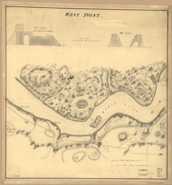
SKU:
smny66
Category:
New York
Related products
Corning, N.Y., 1882 : junction of the New York, Lake Erie, and Western and the Syracuse, Geneva & Corning R.R.'s / C.J. Corbin, field manager.
$
17.95
–
$
47.95
Wildwood Lake Park, Riverhead, Township of Southhampton, Suffolk County, N.Y.
$
17.95
–
$
47.95
Topographic map of West Point, Constitution Island, and vicinity, N.Y.] / T.B.J. Weld.
$
17.95
–
$
47.95
West Point.
$
17.95
–
$
47.95
Search Product or SKU
×
Home
All Products
Historic Maps
American Indian Maps
Birds Eye View Maps
Civil War Maps
Panoramic Maps
Railroad Maps
Revolutionary War Maps
State Maps
Historic Prints
Civil War Prints
Civil War Posters
Historic Portraits
Presidential Portraits
Contact Us
Cart
0
Cart
Close
Updating…
No products in the cart.
Continue shopping