-

Map of eastern Virginia
$17.95 – $47.95 -
Map of Dalton and vicinity
$17.95 – $47.95 -
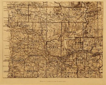
Map of Chinookan territory
$17.95 -
Map of Chickamauga National Military Park. Ferger, Edward
$17.95 – $47.95 -
Map of Chickamauga National Military Park.
$17.95 – $47.95 -
Map of Chickamauga and Chattanooga National Military Park
$17.95 – $47.95 -
Map of Chickamauga and Chattanooga National Military Park
$17.95 – $47.95 -
Map of Chickamauga & Chattanooga National Park
$17.95 – $47.95 -
Map of Chattanooga and environs
$17.95 – $47.95 -
Map of Charleston Harbor showing defenses
$17.95 – $47.95 -
Map of Charleston Harbor
$17.95 – $47.95 -
Map of Charleston and its defences
$17.95 – $47.95 -
Map of Charleston and its defences
$17.95 – $47.95 -
Map of California shown as an island
$17.95 – $47.95 -
Map of California roads for cyclers.
$17.95 – $47.95 -
Map of California
$17.95 – $47.95 -
Map of battlefield of Big Black River Bridge
$17.95 – $47.95 -
Map of battle-field of Manassas, Va.
$17.95 – $47.95 -
Map of Augusta County, Virginia in 1886
$17.95 – $47.95 -
Map of Augusta Co., Virginia, 1738-1770
$17.95 – $47.95 -
Map of Atlanta and vicinity
$17.95 – $47.95 -
Map of Appomattox Court House and vicinity
$17.95 – $47.95 -
Map of Antietam National Cemetary at Sharpsburg, Maryland
$17.95 – $47.95 -
Map of Allatoona, New Hope Church and vicinity
$17.95 – $47.95 -
Map of Alaska, Yukon Territory and British Columbia
$17.95 – $47.95 -
Map of a portion of Missionary Ridge
$17.95 – $47.95 -
Map of a part of Louisiana and Mississippi
$17.95 – $47.95 -
Map illustrating the siege of Atlanta, Ga.
$17.95 – $47.95 -
Map illustrating the siege of Atlanta, Ga.
$17.95 – $47.95 -
Map illustrating the siege of Atlanta, Ga
$17.95 – $47.95 -
Map illustrating the siege of Atlanta, Ga
$17.95 – $47.95 -
Map illustrating the operations at Cumberland Gap, Tennessee
$17.95 – $47.95 -
Map illustrating the military operations in front of Atlanta, Ga
$17.95 – $47.95 -
Map illustrating the first epoch of the Atlanta Campaign
$17.95 – $47.95 -
Map illustrating the first epoch of the Atlanta Campaign
$17.95 – $47.95 -
Map illustrating the first epoch of the Atlanta Campaign
$17.95 – $47.95 -
Map illustrating the defence of Savannah, Ga
$17.95 – $47.95 -
Map and guide of the elevated railroads of New York City.
$17.95 – $47.95


![Map of Chattanooga and environs. Engraved by Buff[alo] Elec. & Eng. Co.](https://www.ushistoricalarchive.com/wp-content/uploads/nc/data/products/im/sm/tn/b81.gif)